
Blue Gold: Let’s start digging – By Hestia Pienaar – Senior Agronomist (Grains and Vegetables)
Responsible and efficient irrigation
A satellite remote sensing study conducted by the WRC reported that 1 334 562 hectares were actively irrigated in South Africa during 2015. The agricultural industry is under constant pressure to account for the allocation of this water and to ensure that irrigation water is applied in an efficient manner (Jarmain et al., 2012).
Agricultural production inputs have risen sharply in recent seasons due to, among other things, pandemics, wars and natural disasters that have plagued the industry. Therefore, in order to ensure profitable farming, it is critical for producers to manage their input costs as efficiently as possible. One important facet of crop production is the implementation of an effective water management plan.
Effective water management is possible
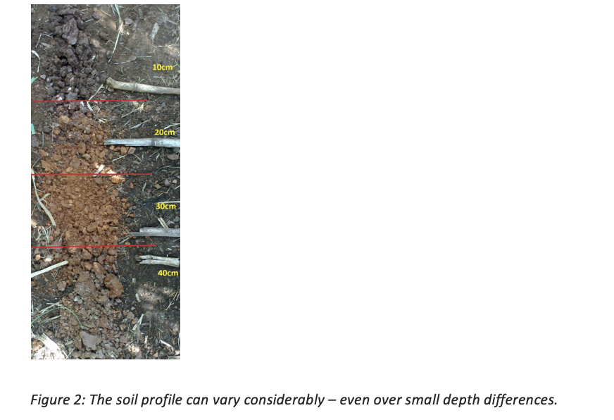
When evaluating the success of fertiliser applications, the impact of water management is often overlooked. This, despite the fact that it is one of thé most critical factors not only effecting high yields, but also impacting crop quality (in certain crops). Young plants are generally over-irrigated, causing applied fertiliser to leach past the crop root zone, becoming unavailable for plant uptake. It is therefore important to know the depth at which the irrigation passes through the soil profile as this would make it possible to effectively manage the nutrients within the root zone of the crop, thereby ensuring optimal yields.
Sometimes the build-up of salts in the soil can cause unfavourable growing conditions. In these instances leaching is recommended, together with a well-balanced fertiliser approach to restore the balance in the soil. The analysis of an ITEST™IRRIGATION water sample makes it possible to determine the number of anions and the salt level in the irrigation water and thus, to formulate a holistic water management plan.
Several methods could be used to schedule in-field irrigation water and choosing one over the other can sometimes be a difficult decision for producers. The most important aspect is that the volume of water that is applied must be monitored, and the moisture content of the soil must be measured or estimated, depending on the method used. Even the most basic hand-feel method is better than no method at all. Fortunately, the Internet (IoT) makes it much easier to monitor multiple sensors as they can be monitored remotely.
These instruments may cause frustration when a device is not properly installed and/or calibrated. Unless a meteorological/model-based approach is followed, it is important to note that most of these soil moisture measurement tools measure only at a single point in the field. Thus, the placement of the device (representative of the land), the correct installation, as well as the calibration of the instrument (relative to the crop being irrigated) are all of utmost importance.
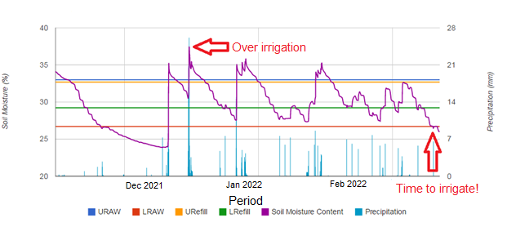
Figure 1: Capacitance probe soil measurement point with rain gauge continuously logging data and sending the data via GPRS.
Know and understand the soil (soil classification) for optimal irrigation decisions
An in-depth understanding of the soil’s physical properties is a very good point of departure when decisions regarding the most appropriate irrigation system and irrigation scheduling strategy need to be made.
With Agri Technovation’s MYSOIL CLASSIFICATION™ service, the physical properties of the soil are determined and presented in detail. Information such as the infiltration rate of the soil (measured in mm/h) can be used to determine the most optimal irrigation system for in-field installation, or the maximum mm/h that could be retained by the soil without surface runoff. The Plant Available Water Capacity (PAWC) zones provide information on how irrigation blocks should be managed differently due to the variation in water retention. Spatial information on the soil texture can also be used, not only for the composition of variable rate fertiliser applications, but also to determine the cycle duration on different irrigation blocks and, in certain cases, even for the application of variable-rate irrigation.
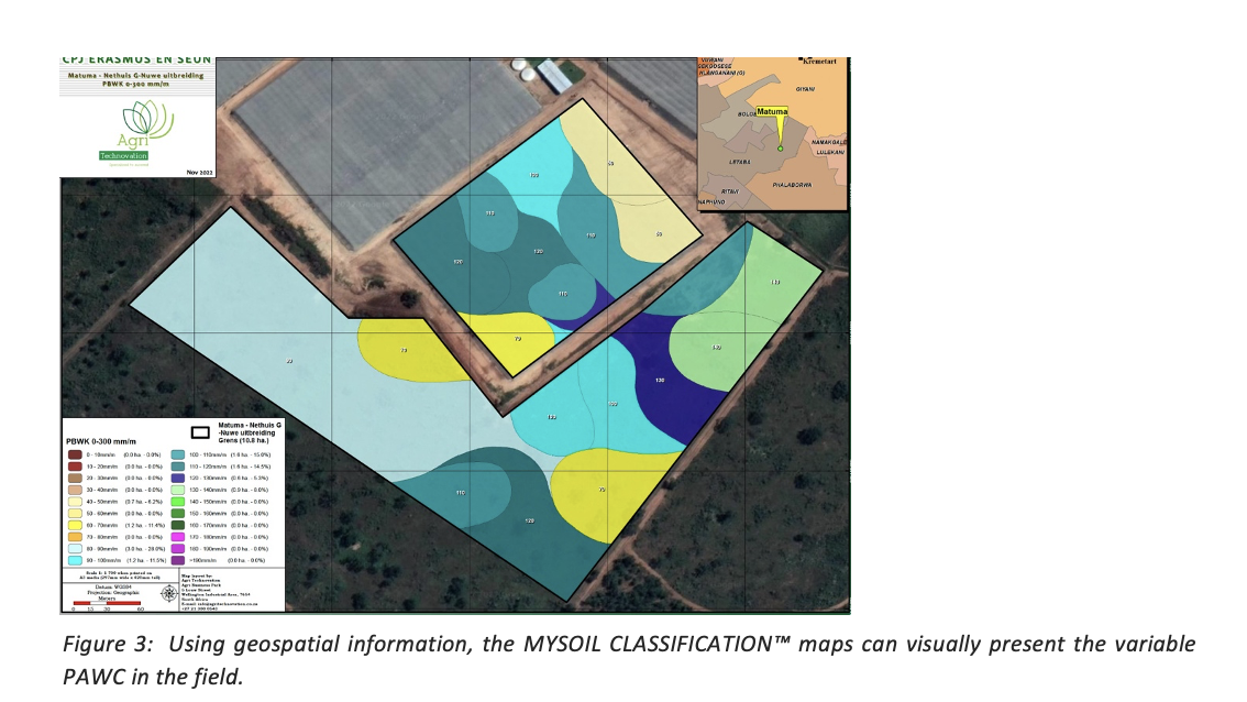
Figure 3: Using geospatial information, the MYSOIL CLASSIFICATION™ maps can visually present the variable PAWC in the field.
Soil classification takes the guesswork out of decisions on soil probe placements, by indicating point measurements that are most representative of the majority of the area of each field. Producers can therefore be assured that measurements at these points will provide the best possible data. In addition, information regarding the installation of drainage in the field (if necessary) is also provided, along with the specifications of the required drainage pipes and the depth and longitudinal dimensions of where they should be installed.
Optimal irrigation
The rate at which crops consume water not only depends on the soil’s properties, but also on the atmospheric demand (climate) and crop demand (evapotranspiration). Therefore, for irrigation scheduling strategies to be effective, all these factors must be considered.
Contact your Agri Technovation Agronomist for more information regarding your water quality, soil properties and the climate- and water demands of your crop, in order to formulate a holistic irrigation management plan for your farm.
References:
- An Earth observation approach towards mapping irrigated areas and quantifying water use by irrigated crops in South Africa (WRC Report No. TT 745/17)
- Jarmain, , Singels., A., Bastidas-Obando, E., Paraskevopoulos, A., Olivier, F.C., Van der Laan, M., Taverna-Turisan, D., Dlamini, M., Munch, Z., Bastiaanssen, W.G.M, Annandale, J.G., Everson, C., Savage, M., Walker, S., 2014. Water Use Efficiency of Selected Irrigated Crops Determined with Satellite Imagery. Water Research Commission, Report No. TT 602/14.